
As I've mentioned before, my research on copper production has led me to be more interested in the history and archaeology of sugar production than I otherwise might be. This interest has exposed me, on several occasions, to a wonderful etymology for the English word "sugar." Allow me to present a brief outline:At some point in the second millennium AD, the technology of sugar production made its way west into the southern Levant, where sugar became a lucrative cash crop in Galilee, the Jordan Valley, and – the important part for our story – the lowlands (aghwar; أغوار) around the Dead Sea (the exact date is a bit unclear, but some time in the 12th century AD is likely for the area around the Dead Sea). One of the key centers of this production was a town to the southeast of the Dead Sea, in Ghawr al-Safi, known then as Zughar. Zughar produced a lot of high-quality sugar, some of which was exported to Europe. Because of its quality, or the amount they produced, or whatever else, the name of the town became so closely associated with sugar that people simply began using the name of the town to refer to the sweetener.It's a neat story, especially for those of us who work in southern Jordan, as it confirms our suspicion that our research area is the center of the world. That's not to say that Zughar wasn't an important place, of course. 19th century scholars like Le Strange (1890:287) noted that, "[t]o the Arab Mediaeval writers, Zughar, the City of Lot, was as well known a place as Jerusalem or Damascus," which isn't that much of an exaggeration. Al-Muqaddasī (1896:2), for example, calls the town a "little Busrah."Getting back on track, I've always wanted to repeat this story, but two things have stopped me from doing so. First, it's simply too good a story, which raises my suspicions. Things that seem too good to be true, as the old adage goes, probably are. Second, it's difficult to trace the origins of the story. For example, the Rough Guide to Jordan tells the story and attributes it to a museum display. Politis repeats the story in brief reports in the AJA and the ACOR Newsletter, but doesn't give a source (Politis 1999:519; Politis 2010:4). I'm sure I've seen it in other sources (and I've been told the story in person on several occasions), but it's difficult to make much sense of where it came from, and I've been looking.I was rather content to regard this story as probably apocryphal without looking into it too much, but this quarter I'm TAing for a world history/writing course covering the period from 1200-1750 AD. One of the themes of this course is the commodification of luxury goods in the Early Modern period, and sugar is, of course, one of the goods that we're discussing. I'm certainly no linguist, but I have a passing interest in etymologies (and I enjoy ruining everyone's fun), so I decided to look into this one a bit to see if there was anything to it (tl;dr version: not really).My first thought, before really looking into it, was that the word for "sugar" is more or less the same in most languages I'm familiar with, including Arabic, and a quick look at the OED more or less confirms this. The first example given in the etymology for "sugar" is the French sucre, and most European languages seem to use basically the same word, derived from the Arabic sukkar (سكر). The exceptions are, of course, English, which replaces the "k" sound with a "g," and Spanish and Portuguese, which also include the Arabic definite article (in Arabic, al-Sukkar (السكر) is read "as-sukkar"). (Messner [1992] points out that leaving the article off is characteristic of Arabic words coming through Italian, apparently.) Ultimately, the Arabic word is derived from a Persian word, which in turn comes from an older Sanskrit word. All of this took place before sugar was produced in Zughar, so already things aren't looking good for our story. Let's not stop there, though.It's still possible that European sources conflated the two words (sukkar and Zughar), linking the two as sugar became more common in Europe. This also seems unlikely. As one example, William of Tyre's Historia refers to the town as "Segor" (see here, Book 10, section VII), but calls sugar zachara (unfortunately this isn't in the Fordham Medieval Sourcebook version, but see here, for example). It doesn't seem likely, then, that these two were closely associated, at least in William of Tyre's mind.The only thing we're really left with is the anomalous English word, with its "g" sound. As the OED notes, though, this isn't entirely uncommon in English, either. The word "flagon," for example, is derived from the Old French word flacon, and even in Middle English was flakon. It seems much easier to attribute the English word "sugar" to this change, rather than to an association with a town that most people in England were certainly unaware of.I wonder, to some extent, if the origins of this story don't have as much to do with the true etymology of the English word "sugar" as they do with a bit of clever wordplay on the name of the town. Obviously there's the "Sugar from a town called Sugar? No Way!" response that we can imagine. Beyond that, though, there's this excerpt from Yāqūt in Le Strange (1890:291): "The name of Zughar, according to the same authorities, is also spelt Sughar and Sukar." It seems fairly straightforward, then, to assume some connection between sukkar and Sukar. The hint to what's going on here, though, is in the fact that Le Strange also calls Yāqūt "Yakut," and generally transcribes the Arabic letter qaf as "k." What he's saying, then, is not that the town is also known as Sukar (سكر) but Suqar (سقر). And therein lies the punchline.You see, one of the sources that gives this alternate name is al-Muqaddasī, who quips, "The people of the two neighbouring districts call the town Sakar" – (read: Saqar, سقر) – "(that is, 'Hell'); and a native of Jerusalem was wont to write from here to his friends, addressing 'From the lower Sakar (Hell) unto those in the upper Firdûs (Paradise)'" (1896:62). So it seems that Zughar was closely associated with hell before they ever produced sugar there. If you've ever been through Ghawr al-Safi in summer, of course, you know this is pretty accurate.Overall, it doesn't seem like there's very much truth to this story. I definitely don't blame people for repeating it. It's certainly, to borrow a term from journalism, a story that's too good to check. Of course, it often turns out when you do check them that they're too good to be true, as well.Works CitedLe Strange, Guy1890 Palestine under the Moslems: A Description of Syria and the Holy Land from A.D. 650 to 1500. London: Alexander P. Watt.Messner, Dieter1992 Further Listings and Categorisations of Arabic Words in Ibero-Romance Languages. In The Legacy of Muslim Spain. S.K. Jayyusi, ed. Pp. 452-456. Leiden: Brill.al-Muqaddasi1896 Description of Syria, Including Palestine. In The Library of the Palestine Pilgrims' Text Society, Vol. III. Pp. 1-103. New York: AMS Press.Politis, Konstantinos D.1999 Deir 'Ain 'Abata and the Ghor es-Safi. Pp. 518-520 in Archaeology in Jordan. Virginia Egan and Patricia Bikai, eds. American Journal of Archaeology 103(3):485-520.Politis, Konstantinos D.2010 Ancient Landscapes of the Ghor es-Sāfī: Surveys and Excavations 1997-2009. ACOR Newsletter 22(2):1-5.
Viewing entries in
Archaeology
Well, I've reached the point where I have a bit of down time to update here (as in, I'm no longer desperately rushing to finish a project I'm behind on), and there are a few things I've been meaning to mention for weeks but haven't had the time for. Now that I have the time, I suppose I should actually do it.The first thing I wanted to point to is this Antiquity Project Gallery by some of my colleagues in the UCSD Levantine Archaeology Lab and CISA3, as well as Chris Tuttle, Associate Director of ACOR. They discuss a short project that involved documenting some of the features at Petra with the digital tools that ELRAP uses in the field. Although I was in Petra the weekend they did this, I was also supervising excavations at KNA during the week, so I spent my weekend relaxing in my hotel and sightseeing, rather than working. Even though I wasn't involved, though, this was a neat collaboration between ELRAP and the Temple of the Winged Lions CRM Initiative (TWLCRM), and it's worth checking out if only for the vertigo-inducing Figure 3 (assuming you haven't already been sent this link 15-20 times like I have). On a related note, Chris also has a paper in the first issue of Journal of Eastern Mediterranean Archaeology and Heritage Studies on the TWLCRM project, which you can take a look at here.The second thing I wanted to mention, and have been meaning to mention for some time now, is that I've had a bit of time to decompress and organize some of my thoughts about WAC 7 at the Dead Sea. So much time, in fact, that I've mostly forgotten what those thoughts were. Luckily, I took some notes that I can refer to.As I've said before, in general the conference was quite interesting. The session I was in, "Deep-time Perspectives on Culture Change in Jordan: Cyber-Archaeology, Production and Exchange," actually had, in case you couldn't tell from the title, many of the same people as the Antiquity Project Gallery I just linked to – enough of them, in fact, that it ran for two sessions (that's 5 hours!) – and was organized by the ELRAP PIs. Although all good, many of the papers seemed to side-step the session theme of "grand narratives," which was somewhat disappointing, as that was one of the (several) things that set our session apart from the other sessions broadly devoted to "digital archaeology." On the other hand, there were papers that confronted this theme head-on, notably a nice summary paper by a bunch of authors associated with the long-lived and inimitable MPP. But enough about us.I don't really want to detail every session I attended, because I went to quite a few, but I found one particularly thought-provoking: a forum called "Science in archaeology: Where to next?" This raised, for me at least, two related issues. The first, which started the general discussion, was about why the Journal of Archaeological Science, as the leading archaeological science journal, has such a low impact factor. One of the responses people gave, and the one that occurred to me first, is that for an anthropology journal, JAS doesn't have a particularly low impact factor. In fact, at 1.914 it probably has the highest impact factor of any archaeology-specific journal (I'm not aware of any over 2 [edit: turns out Radiocarbon is 2.84. Wow!]). There are certainly higher-impact anthropology journals, as this now rather outdated list shows – especially certain four-field journals and many of the bioanth journals – but JAS does pretty well.On the other hand, this concern was primarily raised from the perspective of people in departments other than anthropology (especially in the "harder" sciences) and people who frequently collaborate with non-anthropologists. Everyone knows, to some extent, that impact factors aren't really comparable across fields – for a variety of reasons – but this can make collaboration difficult, especially when it comes to publishing. For example, coming from a field like ecology, where none of the top 20 journals have impact factors below 4, 1.914 probably isn't very appealing. I could ramble at length about the usefulness of impact factors in anthropology and archaeology, but I won't.This brings up the second point, though. The previous discussion prompted two related questions: 1) Why don't archaeologists cite archaeological scientists more and 2) why don't scientists cite archaeological science more? Leaving aside the issue of what archaeological science actually is, if neither archaeology nor science, there was some debate in the room about which of these was a bigger deal. For some, although archaeological science is its own discipline with its own set of questions, these should be integrated more tightly into general archaeological theory. As an archaeologist, rather than an archaeological scientist, this is the view I tend to agree with. Others, however, pointed out that since archaeologists are content to publish in low-impact journals anyway, archaeological scientists should be looking at ways to get cited more often by scientists. Overall, though, the bigger issue seems really to be about the relationship between archaeological science and archaeology generally, which can't be easily answered by simply saying things like, "Well, but archaeology is a science." There's actually a session at the SAAs this year exploring this issue, called "Integrating Archaeology and Theory: How Does 'Archaeological Science' Really Contribute to the Science of Archaeology?" I'd love to attend it, but unfortunately we're giving our paper at the same time, so I can't. I'm curious to hear if anything useful comes out of it, though.
My colleague and good friend Kyle Knabb just posted an abstract for a paper he's giving at the SAAs in Honolulu this year, and I thought, "Oh, I'm also presenting half of that paper. I should probably mention it."So, as Kyle said, we're working together right now to analyze some of the pottery from an intensive survey he led in Wadi al-Faydh, near Petra, in 2009. I was a member of his survey team, so it's exciting to get to analyze a lot of this material finally. As Kyle also mentioned, the majority of the assemblage is made up of rather coarse hand-made pottery (how coarse, you ask? Here's an example collected in Petra by the International Wadi Farasa Project, which gives you an idea of what we're talking about). In addition to not being the most attractive pottery (though I would argue that it has its charms), much of it is also rather difficult to date, especially when it comes from surveys, rather than excavations. One of our arguments, however, is that recent (and in some cases not-so-recent) excavations have produced evidence that enables us to date some of the ceramics Kyle found – especially some distinctive decorated forms – to the 11th and early 12th centuries AD.Our abstract begins with a related problem, which is that evidence of settlement during this period has been somewhat tricky to actually find. To get an idea of this, we just have to check out the DAAHL's (that's the Digital Archaeological Atlas of the Holy Land, for those not yet in the know) Archaeological Periods page. If you zoom to the study area and select Fatimid or Crusader, you see relatively little settlement. If you click Ayyubid, Ayyubid/Mamluk, or Mamluk, the picture is different (and this is also true if you select 'Abbasid/Fatimid, actually). If, as we're going to argue, many ceramics of the Fatimid and Crusader periods have been misclassified as Ayyubid/Mamluk – especially in the south – we have to wonder how good our understanding of settlement patterns in the Middle Islamic I (1000-1200 AD) actually is.These dating concerns have implications beyond simply establishing the chronology of settlement in the region. The biggest issue for me is that sites which weren't occupied during the same period obviously can't be directly connected to one another. This is important for reconstructing local patterns of trade, and one of the things I'm concerned with in terms of my work in Faynan. As the dating of sites becomes more precise, connections that seemed obvious when all the ceramics were lumped together as "Ayyubid/Mamluk" suddenly disappear. But that's a different story for another day. . .
Oh right. I meant to post something here right when this paper came out, but didn't, in part because of the beginning of a new quarter here at UCSD – as well as my first teaching assignment in two years, preparation for WAC 7, and some post-excavation things that needed to be taken care of – and in part simply because I completely forgot. So, here we are, several weeks later, and I'm finally getting around to doing it.Anyway, as I said, I've just published a paper. The authors are myself, Tom Levy – my advisor – and our Jordanian colleague and co-PI of ELRAP, Mohammad Najjar, and it appears in the most recent issue of the Bulletin of the American Schools of Oriental Research. If you have access to BASOR through JSTOR, you a) can just click that link and download the paper and b) have probably already seen the latest issue anyway.The paper is, essentially, a heavily-revised version of my master's thesis, and so represents the culmination of a few years worth of work getting the Islamic Faynan portion of ELRAP off the ground and running. Primarily, what that involved was a (preliminary) analysis of the ceramics collected during the 2002 JHF (the Jabal Hamrat Fidan Project; ELRAP's predecessor) surveys of Wadi al-Ghuwayb and Wadi al-Jariya (I'd link to a PDF, but that doesn't seem to exist at the moment; there's this, though), focusing on the material collected at Khirbat Nuqayb al-Asaymir (KNA), a site I've mentioned before. Our main goals here, in addition to finally presenting the later material from these surveys, were (1) to tighten up the chronology of KNA with a large ceramic sample (1300 sherds exactly) and (2) to put forward some ideas about why copper production was revived in this period.(1) In the paper we argue, based on the ceramics and other evidence, that KNA is primarily an early 13th century site. This isn't a terribly huge redating – most previous work assumed it was primarily a 13th century site – but it has some interesting historical consequences, as we make no assumption that there's an early Mamluk period occupation at the site. We left ourselves a bit of room to adjust this, and pointed out that we couldn't really rule out a later 13th century date, and that the late 12th century also seemed like a possibility. Now that we've excavated the site for two seasons, I'm glad that we left ourselves that room, as the ceramic assemblage has surprised us a bit. In one sense, the excavated ceramic assemblage is rather different from the survey assemblage in terms of the wares that make it up (though I don't want to talk about this too much until we've had more time to go over the material and compile better frequency data), but it's also forcing us to think about dates that are a bit earlier, again. That in itself was interesting, though not entirely unexpected, and we'll be addressing the point in at least one upcoming paper.(2) We were rather dissatisfied with existing explanations for the re-emergence of the Faynan copper industry in the Middle Islamic period, which we thought were either overly dismissive or somewhat anachronistic. Our suggestion, instead, is that mining in Faynan primarily supported the sugar industry. This would have gone primarily toward making boiling vessels – known in Arabic as dusūt – for the cane juice. This image, from flickr user ciamabue, shows an iron boiling vessel from the U.S. It's not an exact match – for one thing, the vessels we're thinking of are made of copper, obviously – but the image at least gives you a sense of scale. 13th century dusut were about 3 feet in diameter and could weigh as much as 550 pounds, so we aren't exactly talking about the Mauviel in your kitchen. This is something that would require a significant amount of copper.So, that's a short summary of two of our key points from this paper. The project is still a work in progress – and will eventually become my dissertation – but the early stages are now published and out there.
Jones, Ian W. N., Thomas E. Levy, and Mohammad Najjar2012 Khirbat Nuqayb al-Asaymir and Middle Islamic Metallurgy in Faynan: Surveys ofWadi al-Ghuwayb and Wadi al-Jariya in Faynan, Southern Jordan. Bulletin ofthe American Schools of Oriental Research 368:67-102.Levy, Thomas E., Russell B. Adams, James D. Anderson, Mohammad Najjar,Neil Smith, Yoav Arbel, Lisa Soderbaum, and Adolfo Muniz2003 An Iron Age Landscape in the Edomite Lowlands: Archaeological Surveys AlongWādī al-Ghuwayb and Wādī al-Jāriya, Jabal Ḥamrat Fīdān, Jordan, 2002.Annual of the Department of Antiquities of Jordan 47:247-277.
Well, it's been a while since I've posted anything here, in part because I've been pretty busy. But following my colleague Kyle Knabb, I thought I'd share an abstract I submitted, and which has been recently accepted. I unfortunately can't attend the ASOR Meeting this year, since I'll be digging in Faynan in November, but I submitted an abstract for the MIRI workshop on the Materiality of the Islamic Rural Economy (they, probably wisely, do not use the acronym MIRE), at the University of Copenhagen. I'll mostly be talking about the results of the small excavation we conducted at Khirbat Nuqayb al-Asaymir in 2011, but I also want to talk about the suggestions I've recently made (and which will, hopefully, be published soon) about the relationship between Faynan and the agricultural economy of Transjordan in the 13th and 14th centuries AD. This will be the first time I've really discussed this in a formal setting (other than submitting it for publication), so I'm looking forward to getting some feedback on it, but also a bit nervous about how it's going to be received, since it is rather speculative.Anyway, I'm looking forward to the workshop. Now all I have to do is write the paper and figure out how I'm going to get to Copenhagen. . .
Here's the abstract, in case you're curious (the title is perhaps a bit obscure, but it's a reference to Levy, et al. [2003]):
References:Levy, Thomas E., Russell B. Adams, James D. Anderson, Mohammad Najjar, Neil Smith, Yoav Arbel, Lisa Soderbaum, and Adolfo Muniz2003 An Iron Age Landscape in the Edomite Lowlands: Archaeological Surveys Along Wādī al-Ghuwayb and Wādī al-Jāriya, Jabal Ḥamrat Fīdān, Jordan, 2002. Annual of the Department of Antiquities of Jordan 47:247-277.Beyond Iron Age Landscapes: Copper Mining and Smelting in Faynan in the 13th Century ADIan W. N. Jones, Thomas E. Levy, and Mohammad Najjar
Although work in the area has been expanding, many aspects of the Middle Islamic period in southern Jordan remain poorly understood. This is perhaps less true of the Faynan district, where several survey projects have investigated and published material from copper production sites of the Middle Islamic period. On the other hand, these projects have understandably tended to focus on periods of more intensive copper exploitation in Faynan, with the Middle Islamic period occupying a somewhat peripheral position in their research. This is unfortunate, as Faynan contains probably the best-preserved Middle Islamic copper smelting sites in the southern Levant.With this in mind, in the fall of 2011 the Edom Lowlands Regional Archaeology Project conducted a sounding at Khirbat Nuqayb al-Asaymir, a copper production site of the 13th century AD. This small excavation revealed the remains of a copper smelting workshop including, to our surprise, a well-preserved smelting furnace. Relatively complete furnaces of any period are rare in Faynan, and this workshop has the potential to greatly increase our understanding of Middle Islamic period copper production.This paper presents the results of the 2011 sounding at Khirbat Nuqayb al-Asaymir, and draws on the available evidence to offer a preliminary reconstruction of the process of copper production in 13th century Faynan. Additionally, building on our previous work, it attempts to locate Khirbat Nuqayb al-Asaymir’s place in several “levels” of regional economy, from the mostly pastoral economic base of Faynan to the expanding economy of central and southern Jordan.
A few days ago, I was checking out the University of Chicago Mamluk Studies Resources page, and I noticed something very exciting. All of the back issues of Mamluk Studies Review, going back to 1997, are now available for free online. The last time I looked, which was late last year sometime, the 2007 volume was the earliest one available, so they've been pretty busy over there. This is especially exciting for me, since our university library owns exactly zero volumes of MSR, so I've had to request a few papers from the earlier issues via Interlibrary Loan. I'm also excited that they now let you download individual papers, rather than the entire issue. I can see some advantages to getting the whole issue, depending on how you store your PDFs (and they still give you the option), but it was a real pain keeping track of them this way in my Papers library.Anyway, this probably isn't news to anyone interested in MSR, but it's nice to see that they've completed the project and all of the back issues are available online. I wish more journals would start doing this.
There's a specific type of work that I often like to do during my morning coffee drinking/news reading ritual. It's a kind of low-intensity reading of things that are interesting, but only marginally related to my current projects. This morning, that took the form of reading a few pieces of William of Tyre's Historia rerum in partibus transmarinis gestarum, a 12th century account of the Latin Kingdom of Jerusalem. (Parts of it are available in translation here, if you're interested.) This inspired me to check Google Books to see if they had a preview of a book I was looking for, so I wouldn't have to go to the library to get it. They didn't, but the search also turned up a book I hadn't heard of before: Unknown Crusader Castles by Kristian Molin. I have no idea whether this book is good or bad, as I only found out about it this morning, but it sounds like something that would have some appeal even beyond an academic audience (or would, at least, if it were available as anything but a $220 hardcover. . . another downside of many academic publishers).So, to determine whether I had much interest in tracking it down, I went looking for some book reviews. The second Google Scholar result was, indeed, a book review, in The English Historical Review. I clicked the review and met, to my surprise, an Ingenta paywall. This wouldn't have surprised me, except that I was already logged into my university VPN, and know I have several EHR papers in my Papers library. Moreover, our library pays for access to a number of journals I regularly read through Ingenta. But no, Ingenta wanted $36 for a two-page book review. That wasn't going to happen, so I figured I would try JSTOR, but didn't have any luck there, either, since the review was from the year after the JSTOR cutoff. Finally, I did the sensible thing and searched my university library's catalog, and found that we subscribe to the EHR through four services, including JSTOR, but that Ingenta isn't one of them. In the end, it took far more time to actually track down the review than it did to read it.There are a few things wrong with this picture, but the one that really stands out to me is that Ingenta wanted $36 for a copy of this review. I understand that the per-article fees are designed to encourage subscription, rather than to actually give access to individual papers, but that's an outrageous amount of money for two pages of book review. In this case, too, it really highlights the problem everyone seems to have brought up with academic publishing: there's really no way for anyone to have access to a lot of this stuff unless they're affiliated with a research institution that has a good library. Even for the most interested non-academic, buying a $36 book review to determine whether you should buy a $220 book isn't worth it.
Here's another thing that came out while I was in the field, and that I meant to write something about. A paper by Stephen H. Savage, Thomas E. Levy and myself, titled "Prospects and Problems in the Use of Hyperspectral Imagery for Archaeological Remote Sensing: A Case Study from the Faynan Copper Mining District, Jordan," was published in the Journal of Archaeological Science. Actually, it's in the Feb. 2012 issue, but through the magic of the publishing process and the internet, this issue is already available. You can get the article from ScienceDirect here, and Steve has made the preprint available on his web site here.As the title implies, one of the things we tried to do in this paper was describe the things that didn't really work, as well as those that did. The inclusion of the section on the Principal Component Analysis is a good example. Some large-scale landscape features were clear, but the false positives and negatives were a bit troubling, and reflect some of the weaknesses of the method and the instrument itself. One of the biggest problems with using Hyperion for archaeological research is the rather coarse spatial resolution. Although the spectral resolution is quite good, with 242 narrow bands (for our purposes only 156 were usable), the spatial resolution is only 30 meters. As a comparison, newer commercial satellites like GeoEye-1 offer resolutions under 2 meters in multispectral bands, and under half a meter panchromatic. What this means is that some things just don't show up on Hyperion images. For example, the primary focus of my research, Khirbat Nuqayb al-Asaymir, is a fairly large site (something like 7 hectares -- 70,000 sq.m.), but it's sparse enough that it's basically invisible on the Hyperion images. This is something of a limitation, and one of the reasons that the focus of this paper is the Iron Age smelting center of Khirbat en-Nahas, which, as you can see if you read the paper, is pretty densely packed with slag mounds.Anyway, I think it's important to publish negative results along with the positive ones, and I'm glad that we did that here. You can, of course, read the paper and judge for yourself.
2012 Savage, Stephen H., Thomas E. Levy, and Ian W. JonesProspects and problems in the use of hyperspectral imagery for archaeological remote sensing:a case study from the Faynan copper mining district, Jordan. Journal of Archaeological Science39(2):407-420.
"I watch and understand that it don't mean a thingThe scorpions might attack, but the system stole the sting" - Crass
It seems that the latest issue of Antiquity included a paper on "recent archaeology" in the form of some graffiti done by the Sex Pistols (Graves-Brown and Schofield 2011). This has actually been out for a few weeks now, but I've been in the field, so it passed me by when everyone was talking about it. Bill Caraher at New Archaeology of the Mediterranean World posted about it, focusing on their points about "anti-heritage" and the, perhaps unintentional, way that the paper highlights some of the contradictions of punk.
For me, though, one of the strangest things about the paper is how much justification the authors feel they need to do. A full half of their abstract, for example, is devoted to stating that the paper is not a joke. Perhaps part of this has to do with the "heritage" context the authors see the paper as coming out of, but in terms of archaeology in general, I don't really see the issue. The Garbage Project predates the Sex Pistols by two years, and at my alma mater, UMass Amherst, Martin Wobst fairly regularly teaches a course called "The Archaeology of Us" dealing with the material culture of the very recent past. Likewise, the subject matter itself doesn't seem to me to need justification. There are already plenty of academic studies of punk. The question really isn't whether punk is a suitable thing for archaeologists to study, but whether archaeologists bring a lot to the table in studying punk.
I'm not really sure about the answer. Certainly, I think we could, but this paper seems to miss the mark a bit. Overall, the focus is on the Sex Pistols and the inhabitants of the 6 Denmark Street flat, which is fine, and there are some interesting insights. None of these seem to have been revealed by the graffiti, per se, but the graffiti provide an interesting context for them. In other places, though, the weaknesses of treating these as "archaeology" is clearer. When the authors state that a portrait was "unidentified and cryptic" (Graves-Brown and Schofield 2011:1393), I can't help but think of a comment my colleague Erez Ben-Yosef once made to me: "This is ridiculous. You aren't dealing with a 15th-century manuscript. Just ask him what he meant!" The big difference between the 6 Denmark Street graffiti and the cave art the authors compare it to is that John Lydon is still alive and playing. Why not just ask him what it meant? Maybe this isn't the case, but it seems that the approach taken here excludes some productive avenues for studying the material.
And that's really the problem, to me. There are a lot of things that could be brought in and connected here, but instead the focus is on whether the site is important enough to be preserved, which is also a bit odd, since their ultimate recommendation is a "DIY" approach to heritage management. In the end, I don't really know how I feel about this project. It's cool, certainly, but the approach is missing something.
2011 Graves-Brown, Paul, and John SchofieldThe filth and the fury: 6 Denmark Street (London) and the Sex Pistols. Antiquity 85:1385-1401.
There are two interesting news pieces about Iraqi antiquities that have been making the rounds recently. The first one is an opinion piece by a U.S. Marine Colonel who argues that looted antiquities from Iraq are being used to fund terrorist activities. It's a short read, and another interesting and depressing perspective on looting in the region. My opinions about the relationship between collecting and looting tend to be somewhat negative, and so I wasn't surprised that Col. Bogdanos points out that a lot of these objects end up seeming "clean" because it's more profitable for museums and auction houses to simply not bother questioning their invented provenances. I'm also not sure I hold much hope that this particular line of argument will be more successful in preventing people from buying illicit antiquities than any other. This isn't Looting Matters, though, and I'm actually bringing the piece up for a different reason. I was initially a bit offended by this statement he makes on the second page:
But here's another reason to stress: and that is that most of the pieces that were looted in Iraq pre-date Islam, pre-date the split between Sunni and Shia Muslims, pre-date Christianity, pre-date even Judaism.I may be a bit biased, but I'm of the opinion that the archaeology of more recent periods is rather important, too. I can see what he's trying to get at, but it still seemed like an odd thing to say. Then, yesterday, I saw this AP story. I think I had heard about the story behind this before, but had forgotten it. When I read this update, though, I did have to wonder if it was at all related to the statement that had surprised me in the first story.
This AP story promoting travel to Acre got forwarded around various archaeology lists the other day, and it got me thinking about my visit to Acre in 2009. I was digging at Tell es-Safi at the time (there's a Crusader castle there, too, called Blanche Garde, although the current excavations focus on the earlier periods), and four of us decided to take a trip to see a few sites in northern Israel, including Acre, Caesarea Maritima, and Megiddo. Acre was definitely a memorable place, and I'd say it's certainly worth a visit if you get a chance.The history of the site is, of course, fascinating. As the article mentions, it was an important Frankish port up until its destruction in the late 13th century by the Mamluks, as part of a larger campaign wherein they destroyed nearly every Mediterranean port in the Levant (Gaza being the one exception). Following that (and its abandonment in the 14th century), the city went through some ups and downs in the Late Islamic (Ottoman) period, and there are a few interesting stories there. Notably, it was briefly a holding of Fakhr ad-Din II, starting in 1610. Hartal (1997:111) describes that situation like this:
Following Fahr ed-Dîn's conquest of the city in 1610, he cleaned the harbor, renewed maritime trade, enlarged the city, and built some new buildings . . . In 1613, however, when the Ottoman Turks campaigned against him, Fahr ed-Dîn ordered the harbor to be filled in and had the city devastated.I've always found this to be an amusing story, in a way. In 1610, he cleans the harbor and expands the city, and three years later fills the harbor in and destroys part of the city. There's also the story, mentioned in the AP article, of Napoleon's failed attempt to take the city in 1799, when it was controlled by Jazzar Pasha. Al-Jazzar (الجزار), incidentally, is not a very nice nickname; it means "the butcher." After Napoleon's unsuccessful siege, Jazzar Pasha understandably decided to fortify the city, using stone taken from the Crusader city as well as 'Atlit castle (Hartal 1997:112; generally, Hartal [1997] has a good, brief discussion of the post-Crusader architectural history of the city).Reading the story, though, I decided to go back and look at the photos I'd taken while I was there. Of course, I got some nice, scenic shots of the city, like this one:
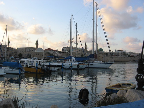 Like most of coastal Israel, it really is a beautiful place. I definitely wouldn't mind spending more time there.I also took quite a few photos of buildings in the Crusader city, like this one:
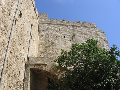 This isn't the most interesting photo I've ever taken, but if you look at it closely you get some hints at the construction phases of the building.Then there's this one, taken in the refectory (dining hall) of the Hospitaller fortress in the old city:
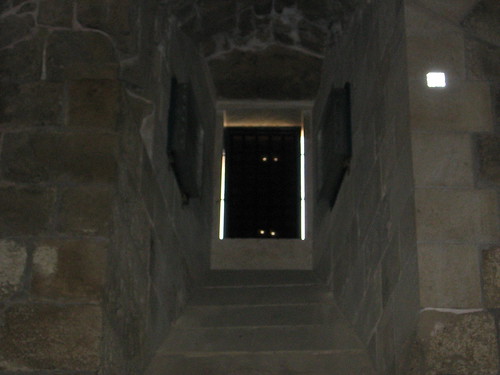 Oh, hello there. . . didn't see you guys up there before.
1997 Hartal, MosheExcavation of the Courthouse Site at 'Akko: Summary and Historical Discussion. 'Atiqot 31:109-114.
As I was doing some reading for a project I'm working on, I happened to come across a decade-and-a-half old Antiquity review of a few survey volumes, mostly dealing with the Mediterranean world (Alcock and Cherry 1996). One of the last points Alcock and Cherry tackle is the dissemination of data – specifically, rather large sets of artifact data – from surveys. A lot of ELRAP team members have recently been involved in discussions of how to do just that, and it's instructive to look back and see what's changed in the past 15 years. They present these options: publish the artifact data as a separate hardcover volume; include the artifact data with the survey volume on microfiche (I'm so glad this never really caught on); publish the artifact data in a separate, but inexpensive, paperback volume; publish the data on a CD-ROM included with the survey volume; or publish the data on the web (Alcock and Cherry 1996:211).Again, it's worth keeping in mind that this review is rather old. Perhaps my perspective is skewed by my age of scarcely more than a quarter of a century and, worse, my academic focus in the first half of the second millennium AD (practically yesterday by archaeological standards), but I think it's important to consider just how long ago this really was in terms of technology. This Wikipedia illustration demonstrates what I'm getting at rather nicely. At the time the review was written, web browsers had only been available to the public for five years, and it had only been three years since the release of a web browser anyone actually used (I'm thinking of Mosaic). Internet Explorer was less than a year old. Surely, in the fifteen years since, web publication has become the obvious choice, even if it wasn't then.Yet, this isn't really the case. To single out one example, only three years ago the Wadi Faynan Landscape Survey publication was released, which included a CD-ROM with supplementary data (Barker et al. 2007). I'm not saying this approach is necessarily bad (though one might object to their decision to include the site gazetteer as a 530 MB PDF), but it still seems strange that web publishing isn't the obvious choice for this sort of data. I can understand the appeal of media – like CD-ROM or, heaven forbid, microfiche – that are directly associated with the survey publication, and I appreciate when artifact data are made available in any form, but I still think web publishing is preferable, not least because it opens up our results to people who are neither associated with large institutional libraries nor able to justify the cost of a large survey volume or subscriptions to all the journals in which preliminary reports may have appeared. (Of course, that's another argument in favor of so-called "Green Open Access", or self-archiving and sharing of publications in non-open journals and books. ELRAP actually does a fairly good job of this; you can download many, though not all, of the recent publications from our lab here.)Alcock and Cherry (1996) mention the Pylos Regional Archaeological Project as an example of a project that was already moving in this direction in 1996. It's still, despite a few flaws, a good example of what data sharing on the web should look like. In part, though, this may be because there don't seem to be that many other examples, or at least examples that I'm aware of, of other projects that share this much data online. ELRAP is, of course, just as guilty of this as any other project, although we're at least currently discussing ways to make our data available to others. Still, it's a bit more complicated than just saying, "OK, I agree to share. Put it all up on the web." I can understand why there would be projects whose members just don't want to deal with it. All things considered, I wonder how close we are to this type of data sharing becoming the norm. It's only been 15 years. . .
1996 Alcock, Susan, and John CherrySurvey at any price? Antiquity 70(267):207-211.
2007 Barker, Graeme, David Gilberston, and David MattinglyArchaeology and Desertification: The Wadi Faynan Landscape Survey, Southern Jordan. Oxford: Oxbow.
It's been a few days since I started and forgot about this post, so this is somewhat old news, but I'm posting it anyway.I didn't notice when it went up a few days ago, but Heather Pringle has a news story in Science (via) which includes a bit about using Google Earth to map looting activities in Jordan (the parts about mapping Guantanamo Bay are also a good read, of course).I thought this all sounded very familiar, and sure enough, I've had the paper from the Journal of Field Archaeology that she cites (Contreras and Brodie 2010) in my Papers library for a few months now, but hadn't gotten around to reading it. So I read it, and actually it's pretty neat. The authors used data from the DAAHL to identify cemetery sites, and then monitored looting activities using the "Historical Imagery" feature in Google Earth. The idea of using time-series imagery to monitor looting isn't really new in itself, of course. Politis (2002) discussed much the same thing, but using aerial photographs instead, at Ghor as-Safi. Google Earth makes this relatively easy, though, especially because the historical imagery is already there. This is a type of project that's been on my mind recently, so it's nice to see that there's some interest in doing this sort of work.References:
2010 Contreras, Daniel A., and Neil BrodieThe Utility of Publicly-Available Satellite Imagery for Investigating Looting ofArchaeological Sites in Jordan. Journal of Field Archaeology 35(1):101-114.
2002 Politis, Konstantinos D.Dealing with the dealers and tomb robbers: the realities of the archaeologyof the Ghor es-Safi in Jordan. In Illicit Antiquities: The theft of culture and theextinction of archaeology. N. Brodie and K.W. Tubb, eds. Pp. 257-267. NewYork: Routledge.
2010 Pringle, HeatherGoogle Earth Shows Clandestine Worlds. Science 329(5995):1008-1009.DOI: 10.1126/science.329.5995.1008
The Peabody Museum at Harvard has what looks like a pretty cool exhibit running now, called "Spying on the Past: Declassified Satellite Images and Archaeology". Looking only at the Peabody page, the name might seem a bit odd, given that, of the six images they show, at least four are not from spy satellites — nor, to my knowledge, were images from those satellites ever classified to begin with — and one is not from a satellite at all. There's a Boston Globe article from a few days ago that discusses the exhibit, though, and it seems like the focus is heavily on the declassified CORONA imagery. It's an interesting concept for an exhibit, and if I'm in Boston before the exhibit closes (which is a lot less likely than it would have been last year) I'll probably stop by to see it.The line about "modern technology" and its "up-to-the-minute dynamic" in the Globe article struck me as rather funny, though. Those CORONA images are 40 years old now — more than that, even, in some cases. More importantly, though, the appeal of CORONA imagery for archaeology isn't its up-to-the-minute technology, but almost the opposite: they give us a relatively low-cost, relatively high-resolution view of what these areas looked like 40 years ago. Although I guess it's still pretty "up-to-the-minute" compared to Tell Brak.
I hadn't heard about the project at Guédelon until today, when I came across this BBC story. Apparently the construction has been going on for over a decade, which I think disqualifies this story as "news" in the traditional sense of the word, but it's still news to me.It's definitely an ambitious project, which I suppose you'd expect given that they're building an entire medieval castle. They're not scheduled to complete the castle until 2023, or more than 25 years after the beginning of construction.You can see a rather striking contrast if you look for the castle in Google Earth (you can see it in Google Maps here, but if you look at it in Google Earth you also get some nice pictures people have uploaded). If you zoom in on the castle, and then move to the southwest, there's a parking lot about as big as the actual castle site. I suppose that's one thing that separates this from a real 13th century castle.
There's an interesting open-access feature in the latest issue of Archaeology — which also has a nice shot of a tomb at Madain Salih on the cover — about using aerial LiDAR to map features hidden under jungle canopy around Caracol in Belize. ("That's great," I hear you say, "but is there anything in there about the Donner Party's dog?" I'm glad you asked, because yes, there's this.) This story isn't really new — it's appeared in several other places recently — but I read about it then, forgot about it, and then read this as I was glancing at the Archaeology site a few days ago, and thought I'd mention it here.The interesting thing about this for me is that, when I was first told about it by one of the undergraduates (now a former undergraduate) working in our lab, it seemed impossible. The active sensors that tend to be good at "seeing through" things like leaves (or sand) are in the low-frequency, large wavelength part of the spectrum, like L-band SAR (Synthetic Aperture Radar), which has been used to do exactly that. Visible light, on the other hand, is much higher-frequency, and not so good at penetrating dense tree cover. From a common-sense perspective, this shouldn't be terribly surprising; it's darker under dense canopy than it would be if you were standing on top of the trees, because visible light doesn't make it through. So, it seems like what you would get if you took scans of an area of dense canopy would be a very nice image of all of those trees. And this is, in fact, exactly what you get (see the "b" view of this National Geographic image, for example).But somehow they did actually manage to map what was under there, and I think the way it works is pretty neat. As the authors put it:
Initially, the lasers are refracted by the tops of trees, producing a detailed record of the forest cover. But treetops are porous, so some photons penetrate deeper, while others reach all the way to the ground and reflect back from the underlying surface terrain—and any buildings or ancient structures on it. The result is an accurate, three-dimensional map of both the forest canopy and the ground elevation beneath it.This was my guess as to the only way it could work when I heard about the story last month, and as it turns out, that is the way it works. Again, it makes sense from the common-sense perspective. The only way that an active sensor in the visible spectrum could penetrate forest cover is the same way that light normally penetrates forest cover: through all the little breaks between leaves. After a quick Googling, I fount out that this isn't an entirely new idea, either, although it was the first I've heard about anyone using LiDAR this way. Its application to archaeological survey still seems rather novel, though, and productive for areas where pedestrian survey is made difficult by forest density. And it's always nice to see aerial remote sensing being used successfully to make accurate archaeological maps.References:
2010 Chase, Arlen F., Diane Z. Chase, and John F. WeishampelLasers in the Jungle. Archaeology 63(4). http://www.archaeology.org/1007/etc/caracol.html.
There's an interesting, albeit quite short, article in the current issue of Science entitled The Map of Altinum, Ancestor of Venice by Andrea Ninfo et al. If you can't access the full text version, you might want to look at the ScienceNOW article -- which is, incidentally, at least as long as the actual article -- to see their figures. As they note, there are no ruins of Altinum; all of that has been robbed out or lost naturally over the years. Their map of the city, then, is based entirely on cropmarks observed in multispectral aerial photographs, and their results are fairly striking.What makes those results striking isn't the spatial resolution of the imagery -- 50 cm multispectral satellite imagery isn't available, but there are several commercial satellites with that kind of resolution in the panchromatic band; even in 2007, when the authors' imagery was obtained, QuickBird approached this kind of resolution -- but the fact that the authors were able to obtain imagery of the area under ideal circumstances. This isn't exactly a new insight -- archaeologists since O.G.S. Crawford have pointed out that the conditions under which aerial photographs are taken can have profound effects on what is visible in the images -- but it's still good to keep in mind. In one sense, this is a good argument for using aerial photography, since it's fairly easy to control when the photographs are taken, but there's also a good argument for satellite imagery in here. If you happened to know that the crops in this area were particularly stressed in July 2007, but didn't manage to get a plane up to take pictures for you, it wouldn't be particularly difficult to find satellite imagery from July 2007.This type of study isn't new, but they've done a really thorough job so far of creating the map of the city. As I mentioned, it's a very short article, but I'm definitely curious to see what will come of this, and how they'll integrate the work they've done so far with the excavations that are presumably to come.References:
2009 Ninfo, Andrea, Alessandro Fontana, Paolo Mozzi, and Francesco Ferrarese.The Map of Altinum, Ancestor of Venice. Science 325(5940):577.DOI: 10.1126/science.1174206